Wednesday, 9 May 2012

West side tour

The training centre closed for a week, so I Carpe Dium-ed and went camping with a couple of friends. This was the last opportunity I will have in my time here to see anything of Namibia, and with such a photogenic country, I had to make the most of it.
The trip was very fast, it was nearly 3000km in 7 days, so it was one day travel, one day look, next day travel etc.
The trip started with a visit to Etosha national park, then on to Swakopmund, a costal town, then down to Sossusvlei, home of the largest sand dunes in the world, if you want a beter idea of where these places are I have once again included GPS coordinates for Google Earth on most shots. if you copy and paste them into google earth in the 'Fly to' tab, it will take you to the exact location.
 Abuid on the Etosha Pan 18°55'48.50" S  16°29'19.21" E

 Ostrich and Orix 19°02'14.35" S  16°20'26.67" E

Quizical Hawk Etosha (same location as above)

Springbok on the Etosha plain 19°00'32.88" S  16°21'47.06" E

 
 Desert trees on the road from Swakopmund to Sossusvlei 23°18'38.04" S  15°30'39.56" E

One of the many amazing dunes at Sossusvlei, there is a car in the shot, most of these dunes are  humdreds of metres high.
24°44'06.79" S  15°17'23.45" E
If you use the exact coordinates shown above, I have put the marker about half way up the front sweeping dune where the people are in the shot.(yes they are there)

 
 We were here for sunrise, so long shaddows were inevitable, Caroline was on the other side of this bowl dune, I have included both of our GPS coordinates.
Caroline 24°45'36.15" S  15°18'03.28" E
Me 24°45'41.15" S  15°17'52.49" E
I was trying to get a bit of footage to show the dunes being created by the wind, if you look at the beginning of the vid you can see it a bit, you can also see how much hard work it is climbing these things, great view, it was worth it. 
24°45'49.51" S  15°18'07.99" E

Sunday, 22 April 2012

What's happening

Hi faithful blog followers, it has been three weeks since I did a post, so I thought I would let you know what is happening here.
I'm working 5 days a week, and I have been given many tasks, I have a regular training session where I train the staff in methods to improve their own performance, using things like feedback tools, effective presentation skills, etc, mainly improving their uptake of computer solutions for their tasks to increase their control over what and how they deliver information to the students.  Some other side tasks are designing a shower block improvement, designing extensions to the workshop areas in Plumbing and Welding, instructing trainers in advanced practical skills, being on the safety committee in an advisory capacity, I was able to give the committee feedback tools and then conduct a review and disseminate the information to the whole of staff, which I used as an introduction to a range of methodologies and technologies to the staff, etc, etc, bla bla bla.
So to answer that often asked question of visitors to this blog, YES I AM WORKING.
As most of you know, I am now in Rundu, it is great to look it up on Google earth if you have it and Wikipedia is good to punch the name into if you are interested in knowing a bit more about it.
I'm putting some photos on here, and I've decided to put the Google earth locations, so that you can see where these shots were taken, I'm interested in a little feedback on if this makes the pictures more interesting, so let me know if you have time.
If you just copy the numbers below the photo which are in green, and paste them into the       'Fly to' window on the top left of the Google earth viewer, and then just click the little magnifying glass icon next to the window, it will take you to the exact location I took the photos from.
One of the flood planes of the Okovango, just a few weeks ago, this was dry with antelope roaming about, but there are crocs in there now, so you may notice the lack of antelope.
Facing North  17°54'42.71" S  19°45'33.80" E if you look at the Google earth shot, it was taken during the dry season, so these floodplains are dry in that view, but you can clearly see where the water does flow in the flood season, as in this photo, this was shot last week.

 This shot is from the same location as the one above, just half an hour later and swung 90 degrees to face west. So this is sunset over the Okovango River, Oh, by the way, there is a bar about 15 metres behind me from this location. If you have looked this location up on Google earth, there is a small pool just south of me and I am under the triangular section of roof, facing west.
This is a great example of the snazzyness of the D700 (my camera) this is the workshops at the campus where I am living and working, this shot was handheld at night on a bright moonlit night, the clouds have good moon glow, one of the 'live on campus' students is going for a stroll, you can see the screen of his phone glowing. (click on the picture to enlarge it)
The building directly in front is an ablution block, and the sawtooth roof behind is the electrical training area. Facing NNE 17°54'05.37" S  19°47'25.63" E

Sunday, 1 April 2012

The Tabasco might be big, but the archery equipment?

Down at the local shops, the price was right and the need for entertainment strong. (no telly here)

Saturday, 24 March 2012

I thought Africa was good before,... but now....

Yes folks, it turns out that Millipedes and Cats are not all that gets big in Africa, anyone who knows my love of this wonderful product will understand my smile. 350ml, the 'normal' bottle of tabasco is 60ml, so nearly 6x normal volume, its like a stubby of tabasco. Yay Africa.

Saturday, 17 March 2012

WOW Victoria Falls

It has been a hectic week, this is my last weekend in Katima Mulilo, next week I an going to Rundu, on the banks of the Okovango River for a change, which will be my home for the next 3 months. Since my time here was running out, I thought I had better take the opportunity while I am so close and go over to Zimbabwe and visit Victoria Falls, Wow I'm so very glad I went, it was amazing, Sandi and I came here in "91" and have very fond memories of it, and it didn't disappoint, although, I was sad that I couldn't share it with my family, especially Sandi.
This 'small' waterfall is the very left hand side of the falls, and is next to the 'devils cateract'.

If you click on any of these shots they should give you a big version, this one is worth it. the photo above this one, is on the very left of the falls. If you look on the road in front of the falls you can see 10 Semi-trailer trucks parked end to end waiting to get through the boarder post, it gives you an idea of the scale, the falls are 1.7km across. The bridge on the right hand side has a little structure in the middle, it is a bungy jump shed, that is where the Australian girl had the cable snap a few months ago, check out the rapids just below the bungy spot, there are crocs too. All of the land on the right is Zambia, I shot this from a chopper.

If you look at the valley with the bridge and follow it to the bend, but look at the building above the end of the valley (you will have to zoom it in and it will be a bit pixelated) you should see what is in the next shot.
Look in the distance between my friend Abuid and me, and you can see the bridge, we are in the garden of the Victoria Falls hotel, a very famous and beautiful hotel at the end of the valley with the bridge.


Looking down the falls.

Then on our way home, as we were going through Chobi national park in Botswana,  we were treated to this, just look at how she dissapears below the grass.

It is a little difficult to see the size of this cat untill you see the next shot.

This is not a technicaly very good photo, (camera shake, as the driver started moving off) however, you can clearly see how lean and fit this magnificent animal is, I have said many times that the ones in the zoo just don't look like this.


You get a much better idea of the power of the falls in this vid. If you look at the first arial shot at the top of the photos above, (the second photo) we start going along the walkway which is opposite the falls and on the left hand end. it starts of dry-ish but as we get further into the middle of the falls, the wind and wet, get very strong. The helicopter ride is a bit boring on vid, but was fantastic in real life, you will have to do it one day, tell me if I'm right.


Sunday, 4 March 2012

On Friday, we had the "End of Year" celebration, which was a little late, but never mind that, it started off with a fantastic meal at the Protea hotel, which is the closest thing you can get to a Hilton or Hyatt in Katima Mulilo. Then a boat cruise down the Zambezi toward the Botswanan boarder, of course I went fishing.
 Just walk down here through this long grass to the boat, oh don't worry about that sign, nobody has been eaten here in ages.

 Yes the beard is real, but the gut is fake.

My fellow shipmates

Wednesday, 22 February 2012

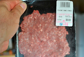
So,... what is this?

Yes my friends, I finallly made another post, in general, I'm just working, that means that I wake up 5 days a week at 6am to get ready for a 7am start, except on Tuesday and Friday, when we have our staff meetings, which start at 6:45am so that we minimise disruption to the students schedule. (most of you can see why my blog posts are thin on the ground)
Today, an anomily to this routine was "what is for dinner?"
So I got the mince out of the freezer and was about to cook it when  I decided to look at the label to see if it might be too old,... I don't remember buying this, but obviously I/ did.
But the question still remains, "What am I about to eat?"
After actually eating it, I recon iy was my favorite,... yep,... Kudu, ...just never know, with a label like that, which screams "Road Kill".
For those that are wondering, the price is about A$1.20.